Each year I look forward to the release of new statistics on Amish Population from the Young Center for Anabaptist and Pietist Studies.
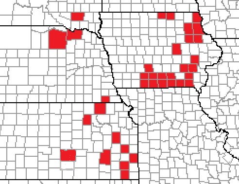
This year they included a document that showed Amish settlements by county in each state. Back in November I started to create a map of the counties to better visualize where Amish settlements are in the US.
I started with Iowa since it is where I was born and my great grandparents had lived in the Amish settlement in Kalona.
 Here is the map I created of the counties in Iowa where the Amish have settlements.
Note: Washington County is not in the data set, but is the center of the Kalona settlement and has been included.
 I also included Kansas, Nebraska and South Dakota at that time.
Late last year I worked on filling in the rest of the map and I also looked for a good base map to use.

For updated maps see: Map of Amish Counties 2022 and Map of Amish Counties 2023
I believe that this map gives a great visual of where the Amish currently live.
It is interesting to see the patterns of where the settlements are.
I have some ideas for some other maps, as maps from different time periods would be beneficial for Genealogy research.
Steven

Map of Amish Counties 2020
On Saturday, January 23, 2021, Braman’s Wanderings wrote:
> vanbraman posted: “Each year I look forward to the release of new > statistics on Amish Population from the Young Center for Anabaptist and > Pietist Studies. This year they included a document that showed Amish > settlements by county in each state. Back in November I started” >
I found this map very interesting. Not many settlements west of the 98th Meridian.
Decade-by-decade maps would be fascinating – but a huge undertaking. I’ve enjoyed the visualization that the Family Atlas program provides for my own genealogical database.
Settlements out west are growing. There is a new one in South Dakota, a couple possible new ones in Wyoming, another new one in Montana and not showing on the map — one in Manitoba. Please, Alabama now plays host to a new settlements. Settlements are doubling about every 20-25 years. Can’t wait for the next map.
I have been checking to see when the Young Center updates their database and will mostly make a new map then.
The Young Center usually publishes an annual update at mid-year. This is the year for their trip-annual conference and it is held in early June. That may affect the timing of the update.
First off, I’ve eaten fried chicken feet, at a bar in Chengdu. I liken them to the Chinese equivalent of Buffalo Wild Wings. Tasty. Second, your county map of the US is remarkable. Do you give permissions for its use (non-commercial) to others? I have a presentation to a group of cooperative extension service agents from several states who are meeting in Shipshewana in late March. The topic are on 3 long-term trends in Amish society — population growth, settlement growth, and shift in occupations (out of agriculture). So, with permission, I shall use it and give proper attribution as follows: Braman S. Map of Amish Counties 2020. Braman’s Wanderings. Published January 24, 2021. Accessed February 23, 2022. https://bramanswanderings.com/2021/01/23/map-of-amishcounties-2020/
Also, if you or any of the folks who follow your postings want to take a look at it, with co-sponsorship by the Young Center for Anabaptist and Pietist Studies and The Ohio State University libraries, you can google to the Journal of Plain Anabaptist Communities for numerous studies about the Amish and, of course, other groups.
All the best.
Joe, you may use my map. You should also mention that the data comes from the Young Center.
Hi Steven, would you give permission for me to use a copy of your map in my PhD thesis? Its the most up to date that I could find. I will provide the proper citation as above. Best wishes, Lettie
Hello Lettie, You do have my permission to use the map. You should cite both the data I used from the Young Center and the visualization of the data from the post.
You forgot BERKS COUNTY PENNSYLVANIA bigtime
Max, I did not forget Berks County, it was not in the data set for 2020 from the Young Center.